Journal of Applied Science and Engineering

Published by Tamkang University Press

1.30

Impact Factor

2.10

CiteScore

Chien-Ting Wu This email address is being protected from spambots. You need JavaScript enabled to view it.1, Cheng-Yang Hsiao2 and Chun-Sung Chen3

1Department of Civil Engineering, National Chiao Tung University, Hsinchu, Taiwan 300, R.O.C.
2Disaster Prevention Technology Research Center, Sinotech Engineering Consultants, Inc., Taiwan 300, R.O.C. 
3Department of Geomatics, Chien Hsin University of Science and Technology, Taoyuan, Taiwan 320, R.O.C.


Received: May 17, 2012
Accepted: January 7, 2013
Publication Date: June 1, 2013

Download Citation: ||https://doi.org/10.6180/jase.2013.16.2.01  


ABSTRACT


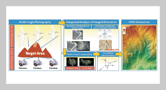
Unconventional photogrammetric measurement technology, which offers features that include no specific camera measurement requirements, few constraints and the ability to take images with different types of equipment, has been used in recent years for emergency natural disaster size assessment and planning disaster relief and mitigation. However, the measurement errors associated with unconventional photogrammetric measurement technology have thus far not been standardized as have those associated with traditional photogrammetric technology. Using the Typhoon Morakot disaster area as a study area, this study used unmanned aerial vehicles (UAV) to overcome the limits of ground photographic shooting angles to conduct low-elevation photography of sediment disaster areas. Using unconventional photogrammetric measurement technology in the field of computer vision, this study established post-disaster environmental three-dimensional terrain data. With the maturation of virtual-base-station real-time kinematic (VBS-RTK) technology in recent years, it was possible in this study to conduct real-time positing by reference to ground control targets to meet goals concerning rapid assessment of disaster situations and disaster relief horizontal accuracy. In addition to introducing relevant technological integration methods, this study explored the technology’s data accuracy and its applications. The empirical results suggest that the horizontal accuracy of the technology studied is within 50 cm and the elevation accuracy is within 1 meter in most cases. Hence, the unconventional photogrammetric measurement technology described in this paper is suitable for use in making quantitative calculations of topographic data from sediment disaster regions as well as rapid disaster relief judgments.


Keywords: Unmanned Aerial Vehicles (UAV), VBS-RTK, Computer Vision, Accuracy


REFERENCES


  1. [1] Doermann, D., “The Indexing and Retrieval of Document Images: a Survey, ” Comput. Vision Image Understand., Vol. 70, pp. 287298 (1998). doi: 10.1006/ cviu.1998.0692
  2. [2] Bunke, H. and Wang, P. S. P. (Eds.), Handbook of Character Recognition and Document Image Analysis, World Scientific, Singapore (1997).
  3. [3] Masaki, I. (Ed.), “Vision-Based Vehicle Guidance,” Proceedings of the 1992 International Conference on Industrial Electronics Control Instrumentation and Automation, New York (1992). doi: 10.1109/IECON. 1992.254518
  4. [4] Bertozzi, M. and Broggi, A., “Vision-Based Vehicle Guidance,” IEEE Comput., Vol. 30, pp. 4955 (1997). doi: 10.1109/2.596628
  5. [5] Broggi, A., Bertozzi, M., Fascioli, A., Conte, G., “Architectural Issues on Vision-Based Automatic Vehicle Guidance: The Experience of the ARGO Autonomous Vehicle,” World Scientific, Singapore (1999). doi: 10.1006/rtim.1999.0191
  6. [6] Lowe, D. G., “Object Recognition from Local ScaleInvariant Features.” International Conference on Computer Vision, Corfu, Greece, pp. 11501157 (1999). doi: 10.1109/ICCV.1999.790410
  7. [7] Lowe, D. G., “Distinctive Image Features from ScaleInvariant Key Points,” International Journal of Computer Vision, No. 60, pp. 91110 (2004). doi: 10.1023/ B:VISI.0000029664.99615.94
  8. [8] Lowe, D. G., “Automatic Panoramic Image Stitching Using Invariant Features,” International Journal of Computer Vision, Vol. 74, No. 1, pp. 5973 (2006). doi: 10.1007/s11263-006-0002-3
  9. [9] Sun, M., “Multiple View Geometry and Traditional Photogrammetry Theory,” Acta Scientiarum Naturlium Universitatis Pekinensis, Vol. 43, No. 4, 453459 (2007). (in Chinese)
  10. [10] Snavely, N., Simon, I., Goesele, M., Szeliski, R. and Seitz, S. M., “Scene Reconstruction and Visualization from Community Photo Collections,” Proceedings of the IEEE, Vol. 98, No. 8, pp. 13701390 (2010). doi: 10.1109/JPROC.2010.2049330
  11. [11] Hsiao, C. Y., Hsieh, P. S. and Chi, S. Y., “Preliminary Study Using Unconventional Photogrammetry to Evaluate the Earthwork Volume-a Case Study of the Landslide Occurred on the Cidu Section of Formosan Freeway,” Journal of Chinese Soil and Water Conservation, Vol. 42, No. 3, pp. 120130 (2011). (in Chinese)
  12. [12] Ko, T., Zhang, Z. X., Guo, T. H. and Wang, C. C., “Aerial Photogrammetry in the Fast Response,” 2010 Workshop on Unconventional Photogrammetry, Tainan (2010). (in Chinese)
  13. [13] Chen, C. C., Cheng, H. Z, Wu, W. H., Lai, G. L. and Xie, Y. D., “The Research of Digital Photography Technology for Measuring the Vibration of the Stayed Cable Parameter Identification,” 2010 Workshop on Unconventional Photogrammetry, Tainan (2010). (in Chinese)
  14. [14] Zhao, X., Huang, R. I. and Wei, S., “Reconstruction on 3D Topography Based on Computer Vision,” Journal of Geological Hazards and Environment Preservation, Vol. 15, No. 2, pp. 7477 (2004). (in Chinese)
  15. [15] Zhang, Y. and Ko, T., “Ortho Updating by Aerial Triangulation Based on the Existing Ortho-Photos and DEM,” 2010 Workshop on Unconventional Photogrammetry, Tainan (2010). (in Chinese)
  16. [16] Tsai, Y. T., The Study on DSM Generated from Point Clouds by UAV Image, Master thesis, National Taipei University, Taipei, Taiwan (2012). (in Chinese)
  17. [17] Tomasi, C. and Kanade, T., “Detection and Tracking of Point Features,” Carnegie Mellon University, Technical Report No. CMU-CS-91-132, Pittsburgh, PA, U.S.A. (1991).
  18. [18] Zhou, K., “Structure & Motion,” Structure in Pattern Recognition, Vienna University of Technology, Faculty of Informatics, Institute of Computer Graphics and Algorithms, Pattern Recognition and Image Processing Group (2010).
  19. [19] Furukawa, Y. and Ponce, J., “Accurate, Dense and Robust Multiview Stereopsis,” IEEE Transactions on Pattern Analysis and Machine Intelligence, Vol. 32, No. 8, pp. 13621376 (2010). doi: 10.1109/TPAMI. 2009.161
  20. [20] Wang, L., Military Digital Topographic Map Editing and Output System Based on MicroStation, Master thesis, The PLA Information Engineering University, Henan, China (2002). (in Chinese)
  21. [21] Hemmert, W., Mermelstein, M. S. and Freeman, D. M., “Nanometer Resolution of Three-Dimensional Motions Using Video Interference Microscopy,” Technical Digest IEEE International MEMS 99 Conference Twelfth IEEE International Conference on Micro Electro Mechanical Systems (Cat No 99CH36291), Orlando, Florida, U.S.A., Jan. 17-21, pp. 302308 (1999).
  22. [22] Wang, M. S., Liu, C. C., Liou, J. L. and Hsiao, F. D., “Surveying Results Analysis on Virtual Base Station Real Time Kinematic Positioning System of e-GPS Base Station Network,” Journal of Cadastral Survey, Vol. 25, No. 2, pp. 121 (2006).
  23. [23] Li, Z., “Effects of Check Point on the Reliability of DTM Accuracy Estimates Obtained from Experimental Test,” Photogrammetric Engineering Remote Sensing, Vol. 57, No. 10, pp. 13331340 (1991).


2.1
2023CiteScore
 
 
69th percentile
Powered by  Scopus

SCImago Journal & Country Rank

Enter your name and email below to receive latest published articles in Journal of Applied Science and Engineering.