




Ji Zhou1,2, Zhuting Tan1,2, Jiaxing Hu1,2, and Chao Xie1,2
1Hunan Provincial Key Laboratory of Intelligent Protection and Utilization Technology in Masonry Artifacts, Hunan University of
Science and Engineering, Yongzhou 425199, China
2Hunan Engineering Research Center of Health Monitoring and Intelligent Utilization in Immovable Cultural Relics, Hunan
University of Science and Engineering, Yongzhou 425199, China
Received: March 23, 2026
Accepted: June 10, 2026
Publication Date: August 05, 2026
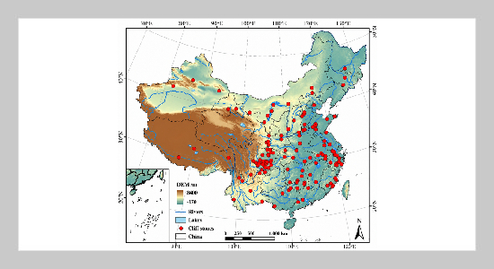
The study area and spatial distribution of the cliff stone carvings
Copyright The Author(s). This is an open access article distributed under the terms of the Creative Commons Attribution License (CC BY 4.0), which permits unrestricted use, distribution, and reproduction in any medium, provided the original author and source are cited.
Download Citation: BibTeX | http://dx.doi.org/10.6180/jase.202611_34.017
Cliff stone carvings are a valuable form of material cultural heritage that integrates stone carving art with writing, calligraphy, historical records, and religious beliefs, serving as tangible evidence of the continuity of Chinese civilisation. This study investigates 146 nationally designated cliff stone carving heritage sites in mainland China. Using geospatial analytical methods-including Kernel Density Estimation (KDE), Geographical Concentration Index (GCI), and Standard Deviation Ellipse (SDE)-combined with ArcGIS spatial analysis, the spatiotemporal distribution patterns and driving factors are systematically examined. The results show that cliff stone carving activities span from the pre-Qin period to the Republic of China, peaking during the Song and Yuan dynasties. Spatially, sites display significant clustering, with core concentrations in Sichuan and Zhejiang and secondary clusters in Hunan, Shandong, and Fujian. Their distribution evolved from early dispersion to later concentration and convergence. Topography, waterways, socio-political development, and religious diffusion jointly influenced this pattern, offering insights for heritage conservation and sustainable regional
development.
Keywords: Cliff stone carvings; Spatiotemporal evolution; Geographic analysis methods; Driving factors
- [1] H. Wu and K. Thongchue, (2024) “Sustainable Development Strategy for Cultural Heritage Conservation of Hengshan Cliff Carving in Hunan Province, People’s Republic of China” Edelweiss Applied Science and Technology 8(6): 6600–6615. DOI: 10.55214/25768484.v8i6.3412.
- [2] L. Yu, (2023) “Analysis of the Relationship Between the Temporal and Spatial Evolution of Henan Grotto Temples and Their Geographical and Cultural Environment Based on GIS” Heritage Science 11(1): DOI: 10.1186/s40494-023-01044-w.
- [3] B. Sun, (2023) “Niches and Sculptures of the Imaginary Realm—Revisiting the Fowan Rock Carvings, Beishan, Dazu” Religions 15(1): DOI: 10.3390/rel15010050.
- [4] J. Fu and H. Mao, (2024) “Study on the Spatiotemporal Distribution Patterns and Influencing Factors of Cultural Heritage: A Case Study of Fujian Province” Heritage Science 12(1): 1–22. DOI: 10.1186/s40494-024-01437-5.
- [5] M. J. Gao and Y. Li, (2023) “Description to the Historical Records Dataset on Human Activity in the Hexi Corridor of China (from Neolithic to Qing Dynasty)” Journal of Global Change Data and Discovery 7(2): 195–203. DOI: 10.3974/geodp.2023.02.08.
- [6] Y. Liu, (2024) “A Study of Stone Carving Workers in Tang Dynasty—Taking Shao Jianhe and Shao Jianchu as Examples” Pacific International Journal 7(1): 18–22. DOI: 10.55014/pij.v7i1.494.
- [7] Q. Ma, T. Liu, Z. Yang, S. Zhang, X. Zhang, M. Sun, and X. Hou, (2025) “The Spatio-Temporal Distribution and Influencing Factors of Cave Temples and Stone Carvings in China” npj Heritage Science 13(1): 311. DOI: 10.1038/s40494-025-01879-5.
- [8] L. Yang, Y. Zhao, W. J. Yuan, et al., (2024) “GIS-Based Analysis of the Regional Typology of Neolithic Archaeological Cultures in the Taihu Lake Region of China” Land 13(2): 244. DOI: 10.3390/land13020244.
- [9] L. W. Jiang and J. Cai, (2023) “Research on the Spatial and Temporal Distribution and Evolution Characteristics of Ancient Architectural Heritage in Southeastern Zhejiang” Sustainability 15(24): 16618. DOI: 10.3390 / su152416618.
- [10] W. X. Chen, L. Y. Yang, J. H. Wu, et al., (2023) “Spatio-Temporal Characteristics and Influencing Factors of Traditional Villages in the Yangtze River Basin: A Geodetector Model” Heritage Science 11(1): DOI: 10.1186/s40494-023-00948-x.
- [11] B. Liu, C. Wu, W. Xu, et al., (2024) “Emerging Trends in GIS Application on Cultural Heritage Conservation: A Review” Heritage Science 12: 139. DOI: 10.1186 / s40494-024-01265-7.
- [12] Y. Yao, X. Wang, L. Luo, et al., (2023) “An Overview of GIS-RS Applications for Archaeological and Cultural Heritage Under the DBAR-Heritage Mission” Remote Sensing 15(24): 5766. DOI: 10.3390/rs15245766.