



1School of Electrical Engineering, Anhui Technical College of Industry and Economy, Hefei 230051, China
2Anhui Provincial Water Resources and Hydropower Survey, Design and Research Institute Co., Ltd, Hefei 230088, China
Received: May 05, 2026
Accepted: July 29, 2026
Publication Date: September 11, 2026
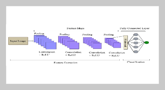
Convolutional Neural Network Architecture.
Copyright The Author(s). This is an open access article distributed under the terms of the Creative Commons Attribution License (CC BY 4.0), which permits unrestricted use, distribution, and reproduction in any medium, provided the original author and source are cited.
Download Citation: BibTeX | http://dx.doi.org/10.6180/jase.202612_35.031
Water level monitoring of rivers, water reservoirs, and dams plays an important role in flood prediction, water resource management, and environmental safety. The conventional water level monitoring techniques include manual observation and sensor-based techniques. The conventional image-based and deep learning-based water level measurement techniques have improved accuracy of the water level measurement system. The dataset used in this research work is the Water Gauge Computer Vision Dataset available in Roboflow Universe, which consists of about 500 real-world water gauge images taken under varying environmental conditions. The proposed water level measurement system differs from the conventional techniques in terms of the usage of YOLOv8-based gauge region detection, hybrid Convolutional Neural Network (CNN)-Optical Character Recognition (OCR) for digit detection, and classical computer vision techniques like edge detection and Hough transform for accurate waterline detection. The experimental results show high detection accuracy with Precision 0.960, Recall 0.955, F1-score 0.958, Accuracy 0.969, and mAP 0.970. The system has high estimation accuracy as well, as shown by MAE 0.036 m, RMSE 0.081 m and MAPE 3.55%, which shows minimal prediction error in the results.
Keywords: Automated Water Level Monitoring, YOLOv8, Gauge Scale Detection, Computer Vision, CNN-OCR, Image Processing
- [1] G. Qiao, M. Yang, and H. Wang, (2022) “A water level measurement approach based on YOLOv5s” Sensors 22(10): 3714. DOI: 10.3390/s22103714.
- [2] Z. Xie, J. Jin, J. Wang, R. Zhang, and S. Li, (2023) “Application of deep learning techniques in water level measurement: Combining improved SegFormer-UNet model with virtual water gauge” Applied Sciences 13(9): 5614. DOI: 10.3390/app13095614.
- [3] W.-C. Liu and W.-C. Huang, (2024) “Evaluation of deep learning computer vision for water level measurements in rivers” Heliyon 10(4): e25989. DOI: 10.1016/j.heliyon.2024.e25989.
- [4] C. A. G. Santos, M. A. Ghorbani, E. Abdi, U. Patel, and S. Sadeddin, (2025) “Estimating water levels through smartphone-imaged gauges: A comparative analysis of ANN, DL, and CNN models” Water Resources Management 39(4): 1639-1654. DOI: 10.1007/s11269-024-04038-w.
- [5] N. Mohamadiazar, A. Ebrahimian, and H. Hosseiny, (2024) “Integrating deep learning, satellite image processing, and spatial-temporal analysis for urban flood prediction” Journal of Hydrology 639: 131508. DOI: 10.1016/j.jhydrol.2024.131508.
- [6] D. Zhang and J. Tong, (2023) “Robust water level measurement method based on computer vision” Journal of Hydrology 620: 129456. DOI: 10.1016/j.jhydrol.2023.129456.
- [7] W. Jung, J. Kim, H. Jo, S. Lee, and B. Kim, (2025) “Video-based deep learning approach for water level monitoring in reservoirs” Water 17: 2525. DOI: 10.3390/w17172525.
- [8] X. Blanch, J. Grundmann, R. Hedel, and A. Eltner, (2026) “AI image-based method for a robust automatic real-time water level monitoring: A long-term application case” Hydrology and Earth System Sciences 30(3): 797-824. DOI: 10.5194/hess-30-797-2026.
- [9] H. Guo, Y. Wang, and Y. Zhang, (2022) “A water gauge scale capturing method in tidal well based on image recognition” Journal of Physics: Conference Series 2320(1): 012029. DOI: 10.1088/1742-6596/2320/1/012029.
- [10] J. H. Lee and J. K. Jung, (2024) “Development of image-based water level sensor with high-resolution and low-cost using image processing algorithm” Sensors 24(23): DOI: 10.3390/s24237699.
- [11] C. A. Krabbenhoft et al., (2022) “Assessing placement bias of the global river gauge network” Nature Sustainability 5(7): 586-592. DOI: 10.1038/s41893-022-00873-0.
- [12] N. A. Muhadi, A. F. Abdullah, S. K. Bejo, M. R. Mahadi, A. Mijic, and Z. Vojinovic, (2024) “Deep learning and LiDAR integration for surveillance camera-based river water level monitoring in flood applications” Natural Hazards 120(9): 8367-8390. DOI: 10.1007/s11069-024-06503-6.
- [13] Roboflow. Water gauge dataset overview. Roboflow Universe. Accessed 28 March 2026. 2026.
- [14] G. Bai et al., (2021) “An intelligent water level monitoring method based on SSD algorithm” Measurement 185: 110047. DOI: 10.1016/j.measurement.2021.110047.
- [15] L. Liang et al., (2023) “Study and application of image water level recognition calculation method based on Mask RCNN and Faster R-CNN” Applied Ecology and Environmental Research 21(6): 5039-5053. DOI: 10.15666/aeer/2106_50395053.
- [16] X. Wang, Z. Li, Y. Zhang, and G. An, (2023) “Water level recognition based on deep learning and character interpolation strategy for stained water gauge” River 2(4): 506-517. DOI: 10.1002/rvr2.69.
- [17] R. Qiu, Z. Cai, Z. Chang, S. Liu, and G. Tu, (2023) “A two-stage image process for water level recognition via dual-attention CornerNet and CTransformer” The Visual Computer 39(7): 2933-2952. DOI: 10.1007/s00371-022-02501-6.